Measurements of environmental conditions

For the use of offshore wind energy, a profound knowledge of the prevailing environmental conditions at existing and future sites is substantial. In the different project phases from planning to implementation to operation, different information is required. Fraunhofer IWES acquires, analyzes and evaluates all relevant environmental conditions for offshore power plants: wind, waves, currents and soil conditions.

The required site conditions depend on the respective project phase. In accordance with requirements specific information about the site from different sources is used. At an early time of planning Fraunhofer IWES creates an overall concept for the collection and analysis of data. In the design phase of the plant knowledge of design conditions like the extreme values of environmental parameters is essential for estimating the loads on the turbines. Similarly, an exact knowledge about the soil conditions for the design of foundations is vital. For offshore wind farms a highly accurate acquisition of wind data at high altitudes and the combination of measured with modeled data allows more planning certainty for the wind farm layout. 

Measurement campaigns for an offshore wind resource assessment with the in-house developed Fraunhofer IWES Wind Lidar buoy include the complete yield assessment for the development of an offshore wind project. The floating system integrates a ZephIR 300 or a Wind-cube® v2 Lidar device in an adapted marine buoy. Its compact design, an autonomous power system and an efficient data processing and communication system ensure reliable and flexible offshore wind measurement campaigns at minimal costs. The motion correction algorithm guarantees high data accuracy and measurement uncertainties similar to those for offshore mast measurements. The Wind Lidar buoy delivers reliable measurement data for all relevant project phases - including planning, installation and operation.

Fraunhofer developed a correction algorithm that allows LiDAR systems to carry out measurements even on moving structures. The algorithm subtracts the buoy’s own movement from the measurement values.

Data sheet "Fraunhofer IWES Wind Lidar Buoy – Offshore Wind and Ocean Measurements"

Video: Offshore wind measuring campaign with a LiDAR buoy


SERVICES

• Wind velocity measurements from 10 to 200+ meter
• Additional measurements available: waves, currents, temperature etc.
• Full service contract including permission, deployment, service, data transfer, quality control
• Wind resource assessment based on these data
• Measurement campaigns from one week to one year possible.

Ship-based LiDAR system


For flexible wind measurements under offshore conditions, the "ship-based Lidar system" facilitates the application of standard wind lidar technology on ships. Whereas measurements from fixed platforms or anchored buoys are a recommendable solution for long-term applications, a ship-based solution is best when a ship is in use at the location of interest anyway or when a measurement is needed for a rather short period only.

A prerequisite for a precise measurement from a moving ship is the correction of the measured data with respect to the concurrent motions. Hence, an integrated motion-measurement system is an essential part of the developed Ship-Lidar System. Data for the up to six degrees of freedom of the system placed on the ship are recorded with high resolution, processed and applied for a correction of the concurrently recorded lidar data.

Exact knowledge of local construction site conditions is an important prerequisite for the planning and development of offshore wind farms. This is the basis for the choice and optimal dimensioning of wind energy turbine support structures. As the foundation work costs have a comparatively large share of the total offshore wind energy turbine costs this area has a great cost optimization potential.

Established investigation methods such as geological drilling and penetration tests deliver important foundation-relevant information, however, they are limited to the respective test sites. Using these methods it is only partially possible to gain information on construction site conditions in the surrounding areas; this can be inadequate and especially for foundation structures such as ackets or tripods.

In contrast, geophysical methods give an extensive, comparatively fast and cost effective overview of the foundation conditions, however, they do not allow direct statements to be made concerning foundation characteristics. One of the aims of the Offshore Site Assessment, Ground group to consider the subject of foundation assessment holistically and to usefully and effectively apply the different methods in relation to each other.

In the geophysics field Fraunhofer IWES has developed a multi-channel seismic measuring process which is particularly tailored to offshore wind energy requirements. Common problems in conventional measuring processes such as inadequate signal penetration and the bad mapping of complex structures have been overcome. We have successfully conducted geophysical surveys for several customers for offshore wind farms with this method. The results show unprevailed resolution and signal penetration in the characterisation of subsoil conditions for offshore wind farms

Regarding geotechnical offshore foundation structure dimensioning, the working group offers in-situ surveying methods (CPT) and geotechnical as well as both monotone and cyclical laboratory testing in order to characterize sea-bed samples. The parameters gained here are the basis for assessment and the foundation construction dimensioning process. The assessment is carried out pursuant to BSH standards, encompasses cyclic loading and is, according to client’s wishes and requirements, supported and safeguarded through implementing FE procedures.

Data sheet "Ultra High Resolution Seismic System - Fraunhofer IWES Subsurface Investigation"

Simple-shear cell

SERVICES

• Cyclic triaxial test
• Cyclic direct simple shear test DSS
• Consulting on using the test results in the technical design
• Consulting on planning and development

According to DNV GL OS-J101 and many other recent guidelines and national requirements, geotechnical soil investigation consists of in-situ testing of soil and of soil sampling with subsequent laboratory testing.
All this shall provide the following types of geotechnical data for all important layers:

• Data for soil classification and description
• Shear strength and deformation properties, as required for the type of analysis to be carried out
• in-situ stress conditions

The laboratory test program for determination of soil strength and deformation properties covers a set of different types of tests and a number of tests of each type, which will suffice to carry out a detailed foundation design. For mineral soils, such as sand and clay, direct simple shear tests and triaxial tests are relevant types of tests for determining strength properties.

Since the offshore wind turbines structures are subjected to waves and wind, the effects of cyclic loading on the soil properties shall be considered in foundation design. Cyclic shear stresses may lead to a gradual increase in pore pressure. Pore pressure build-up and the accompanying increase in cyclic and permanent shear strains may reduce the shear strength of the soil. These effects have to be taken into account in the assessment of the characteristic shear strength for usage in the design within applicable limit state categories as well as in the assessment of permanent foundation rotations.

Fraunhofer IWES in collaboration with cooperation partners offers advanced geotechnical laboratory testing and provides assistance in planning of cyclic and static test programs for determination of soil properties under a range of load conditions to be covered by the foundation design and installation procedure.

Data sheet Geotechnical Laboratory Investigations 

Aquadopp units measure the direction and speed of the current
© Jan Meier

Detailed characterization of the current and wave conditions is vital for designing offshore wind turbines. Site assessment with accurate prediction of the expected energy output lowers the technical and financial risks for project planners and investors. The current conditions around the foundations of offshore wind turbines determine not only the loads on the structure but also cause sediment transport close to the structure which can lead to pitting.

Detailed analysis of current data has highlighted the complex spatial and time variability of sea currents. The cause of current variations are the effects of turbulence, waves and wind on the avarage current. As a consequence, the electrical output of the turbine varies considerabely and high dynamic loads on the rotor and structure can occur. Accurate analysis of the current field is limited by the low spatial and time resolution of the ADCP (Acoustic Doppler Current Profiler) method that is currently used - but can be improved significantly by using acoustic measuring units. In the direct vicinity of the foundation of an offshore wind turbine they allow detailed investigation of the interaction between the structure and current and the resulting sediment transport.

© Fraunhofer IWES
The Manta Ray system uses diffracted energy to map boulders in the sub-seafloor to depths of 50-100 m below seafloor in various geological units.
© Fraunhofer IWES
Final interpretation results showing identified targets in different geological units with maximum localization errors.
© Fraunhofer IWES/Pascal Behning

The new Fraunhofer IWES Manta Ray system – cost-efficient seismic diffraction imaging for sub-seafloor boulder de-risking of offshore construction sites

Glacial boulders present serious challenges for offshore wind farm installation

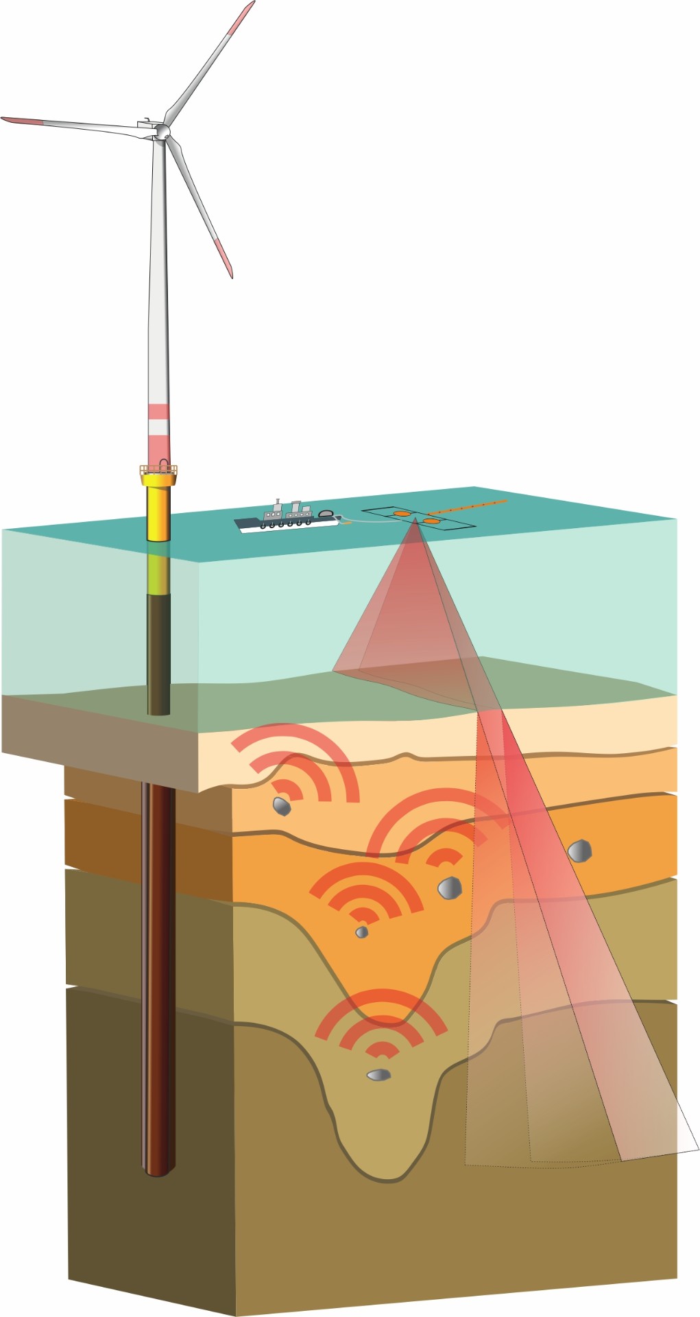
The scale of offshore wind turbine generator (WTG) foundations and offshore environmental conditions, pose serious challenges for the construction of offshore wind farms. Especially glacially influenced regions, e.g. in northern Europe, show difficult geological conditions for the installation of monopiles or other foundation types. The identification of widespread boulder-prone glacial sediments in the shallow sub-seafloor is a common challenge for pre-site surveys in these areas. Such boulders show sizes of <1 m to >5 m and may occur in various geological units. Boulders may also occur on non-glaciated margins, e.g. in conglomerate layers, volcanic deposits or subsiding beach rocks, which pose similar challenges for the installation of offshore infrastructure.

Encountering boulders during pile installation may lead to damage of the foundation or to a complete refusal of the pile installation process, incurring considerable remediation costs. Associated stand-by costs for ships and replacement piles further increase the expenses to mitigate boulder-related installation issues.

Conventional geophysical methods including sub-bottom profilers, single-channel seismics and magnetic measurements cannot reliably detect and localize sub-seafloor boulders. Thus, even extensive state-of-the-art geophysical site surveys leave a considerable remnant risk of undetected boulder occurrences that could obstruct foundation installation and lead to an increase in costs and delays in wind farm development.

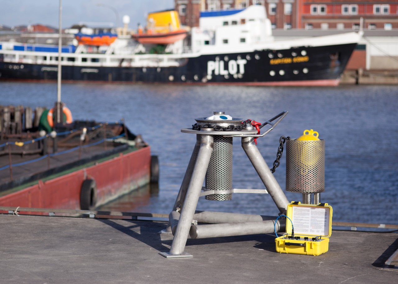
In order to address this technological gap, Fraunhofer IWES, jointly with the University of Bremen, developed the Manta Ray system, a new geophysical tool for offshore sub-seafloor boulder surveys.

The Fraunhofer IWES Manta Ray system

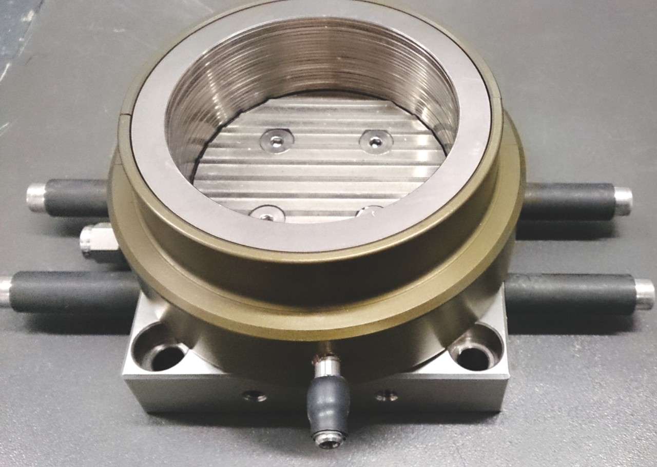
The novel Manta Ray data acquisition system in conjunction with a highly specialized data processing procedure is capable of reliably detecting objects, i.e. boulders, within the marine sediments to full WTG foundation depth. It is based on multichannel seismic principles using a custom-designed array of hydrophones for signal recording and an appropriate high-frequency seismic signal source. While conventional seismic methods commonly image sub-surface structures utilizing reflected energy, the Manta Ray system images diffracted energy, which is caused by individual objects in the sub-surface. Objects are reliably detected down to a depth of ~100 m below the seafloor in shallow water areas of the North and Baltic Seas.

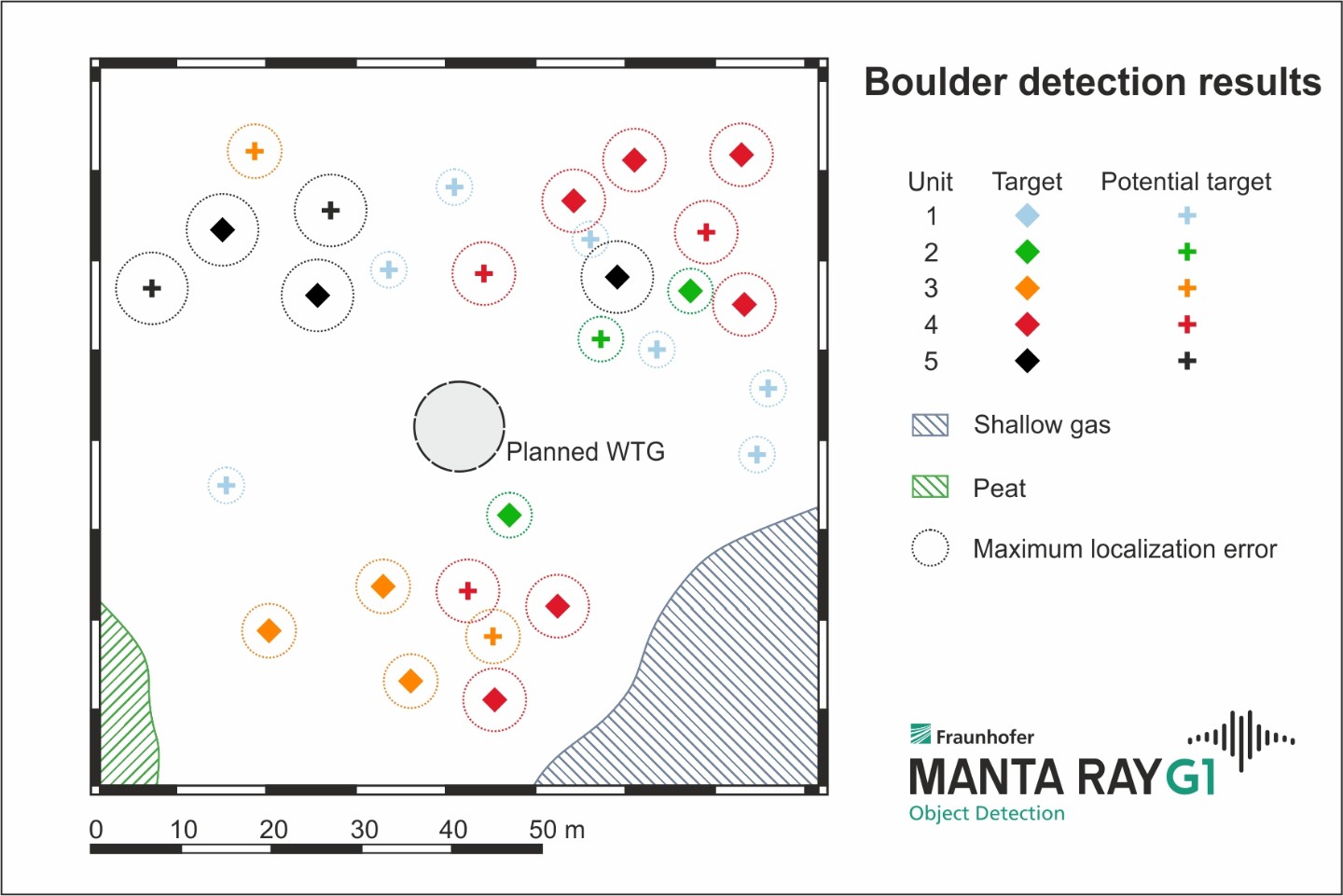
Simultaneously to the acquisition of seismic diffraction data, the Manta Ray is capable of acquiring ultra-high-resolution (UHR) 2D seismic reflection data, used for a detailed geological interpretation of the survey area. The combination of high-precision positioning systems, a custom-designed survey strategy and an effective data processing routine, based on proprietary algorithms, results in a high-resolution seismic diffraction and UHR seismic reflection dataset for subsequent interpretation. The versatile interpretation workflow integrates the statistical analysis of seismic diffraction data and a stratigraphic interpretation of geological units from the seismic reflection data. The results comprise the locations and burial depths of identified objects including localization error estimates and a geological interpretation of identified objects within their respective sedimentary units. These results can be used to avoid areas of high boulder risk via micro-siting of foundations.  

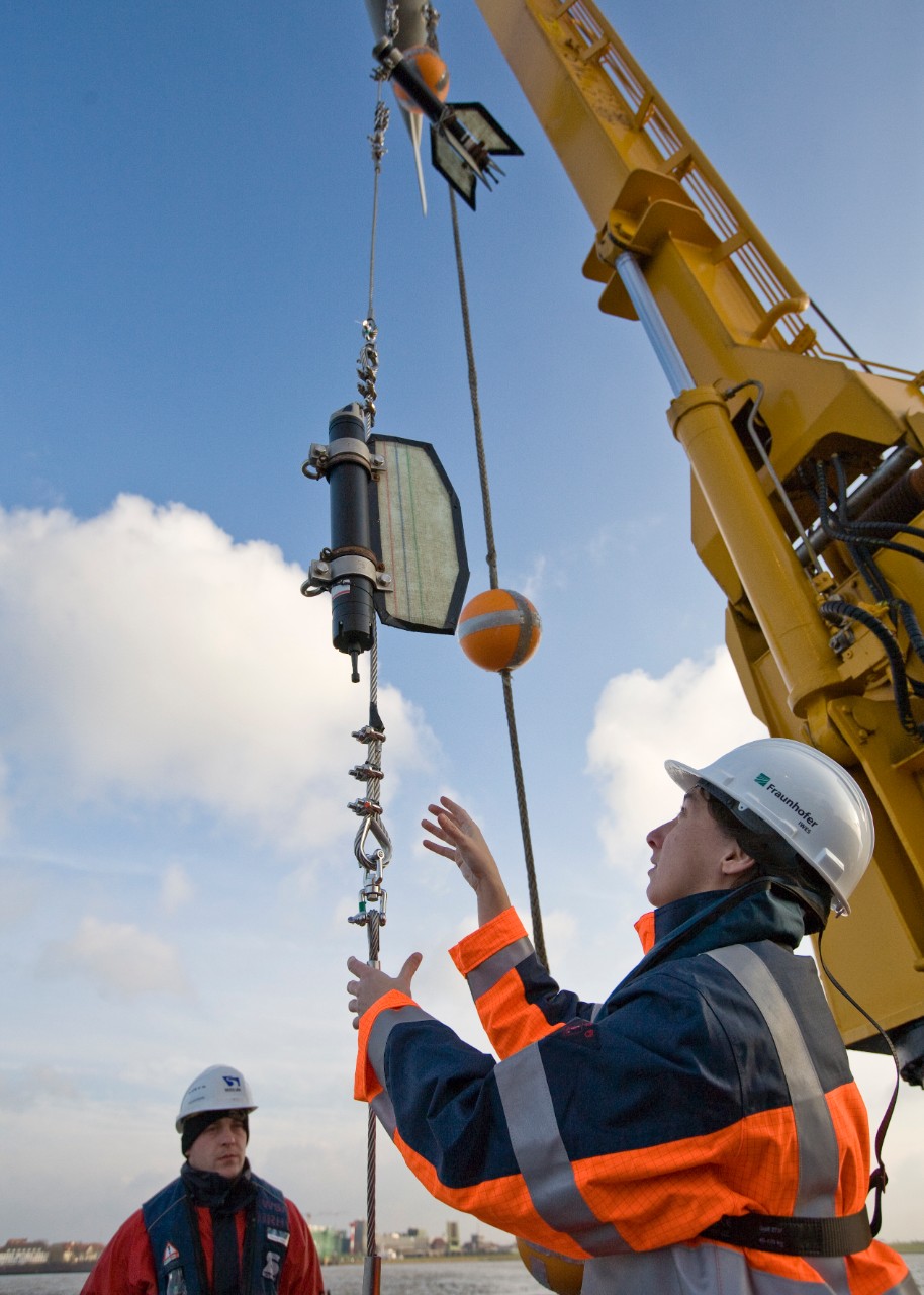
The Manta Ray system has been employed in a number of sea trials in the German North Sea and Baltic Sea sectors in order to validate the method. Subsequently, a first commercial application could be carried out successfully in 2019.

Typical survey work using the Manta Ray targets limited areas around planned WTG locations (e.g. 100 x 100 m), requiring between 6 and 12 hours survey time, depending on overall survey layout, vessel mobilization and other campaign constraints. Full field surveys are possible due to high survey speed of up to 5 knots and swath imaging capabilities of the Manta Ray. Data processing and interpretation is carried out in close cooperation with the client to ensure result-oriented work and individually designed deliverables. Processing times are on the order of several weeks, owing to sophisticated data processing procedures and careful interpretation of results. The final results allow the client to ensure the safe, time- and cost-efficient construction of offshore infrastructure through the de-risking of construction sites with regard to boulder occurrence. The system can easily be adjusted to the sizes of boulders that are of interest for individual projects as well as the depth below seafloor that is targeted.

The Manta Ray system allows a boulder risk-assessment and –mitigation for offshore construction projects such as:

  • WTG installations
  • Offshore station foundations
  • Cable corridors
  • Dredging operations

Benefits of the Manta Ray system for boulder surveys:

  • Reliable sub-seafloor object detection through point diffraction imaging
  • Detection of objects (0.5-5 m) within sediments down to ~100 mbsf
  • Efficient surveying with swath coverage
  • High localization accuracy due to synthetic aperture processing
  • Fit-for-purpose risk assessment for offshore construction projects
  • Secondary UHR 2D/3D seismic site survey dataset

Data sheet "Manta Ray G1 - Sub-seafloor object detection"